Atmosphere Live
The Fullervision Enterprises repository for weather and radio propagation
Today's forecast
Fuller's local forecast
Fuller's DeepLook weather forecast is on indefinite hiatus.
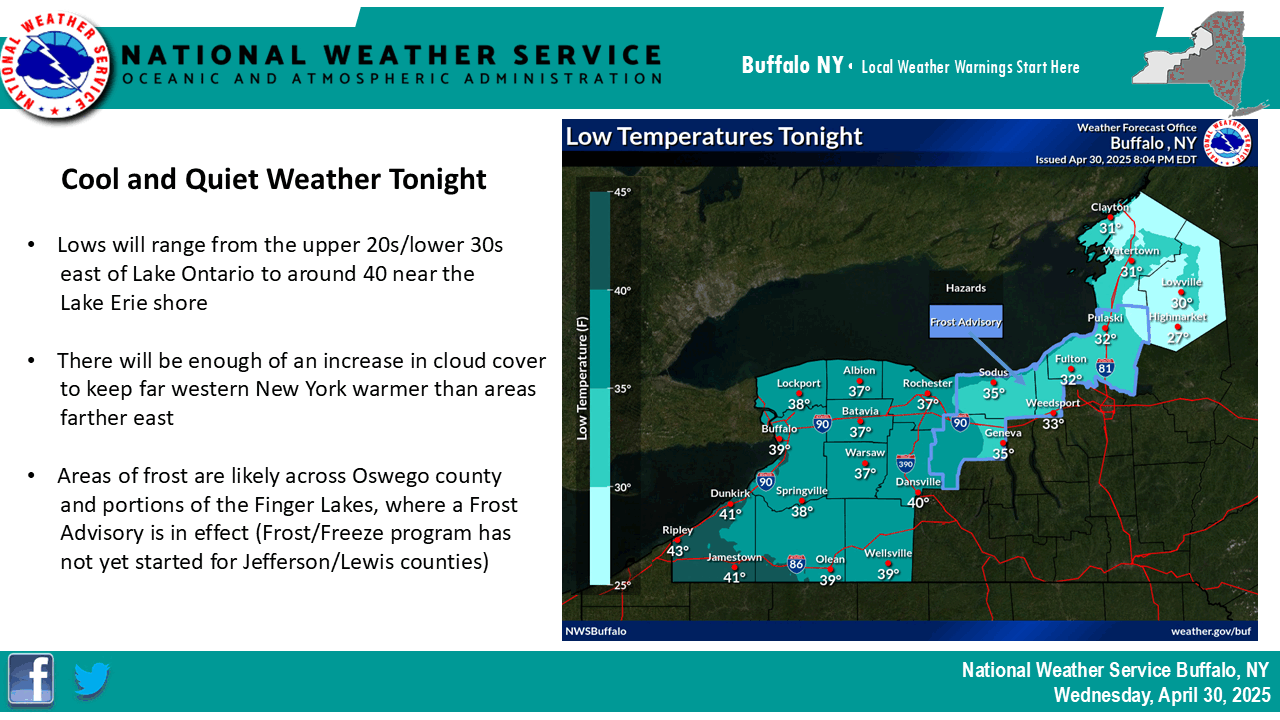
Official local forecast infographic
From the National Weather Service WFO in Buffalo, NY:
Official national forecast map
From the Weather Prediction Center

RADAR and satellite—Great Lakes
RADAR from the U.S. NEXRAD network
Satellite from GOES-17, GeoColor with lightning overlay


Hydrology
-
Water temps
- Lakes Erie and Ontario
- Owasco Lake
- Seneca Lake
- Cayuga Lake
- Cattaraugus
Creek
- Allegheny
Reservoir (upper)
- Kinzua
Dam (Lower Allegheny Reservoir)
- Great Lakes
Ice Cover (U.S. GLERL)
- Great
Lakes Ice Cover (Canada)
-
Soil and ground water levels
- AHPS river level monitoring
by site
- USGS
groundwater level monitoring by site
- NASA soil/groundwater measurements
- Tides
- Soil temperatures are available via NYS Mesonet (see below)
-
Astronomy
- NOAA
Solar Calculator for sunrise and sunset
- USNO Lunar
Phases, Seasons and Eclipses
- Space weather (solar
geomagnetic radio disruption)
Weather on Mars: Gale Crater (Curiosity) - Weather on
Mars Elysium Plain (InSight)
-
Climatology
- ACIS local climate data and graphing
-
Historic analogs to predicted weather
-
Top ten dates in which weather matches the current medium-long range forecast, updated 3 p.m. daily
- 6-10 days
- 8-14
days
Land-based and air-based observations
-
Seasonal / misc
- Growing
degree days tracker (Northeast US)
- UV Index
- Air
Quality Index (New York)
- Pollen Counts
- Spring foliage reports (NPN)
- Fall Foliage Reports (New York)
- Winter road surfaces (New York)
- Winter ski slope surfaces (New York)
- Winter snowmobile trail surfaces (New York)
- Snow cover
- Electric power outages (National Grid)
- Electric power outages (NYSEG)
-
Observations
- NYS Mesonet ©
- National
surface observations (MADIS)
- Weatherbug
(observations at schools) ©
- WunderMap (personal weather stations) ©
- Buoy data (NDBC)
- Lightning detection (NLDN) ©
-
Upper air, weather balloons
- Map
generator (weather balloon)
- Soundings
- Cross-section and potential temperature (isentropic)
- ACARS/AMDAR airplane soundings
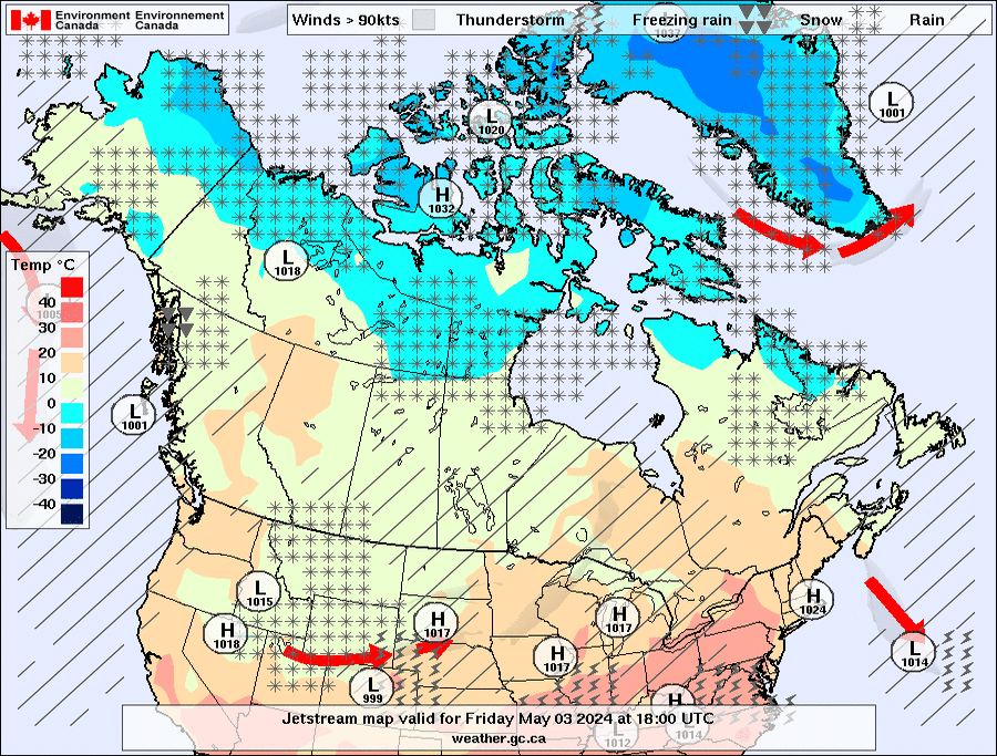
Jet stream
Published by Environment Canada
Forecast models
-
Short range,
mesoscale -
2 days or less, 15-60 minute steps
- HRRR (high-resolution rapid refresh)
- RAP (rapid refresh)
- RPM (rapid precision mesoscale)
- WRF-ARW (advanced research WRF)
- HRDPS (high-resolution deterministic prediction system)
-
Medium range
-
2-8 days, 3-6 hour steps
- NAM (North American Mesoscale)
- RDPS (regional deterministic prediction system)
- HYSPLIT
(trajectory model)
-
Extended range
-
10-16 days
- GFS (global forecast system)
- GDPS (global deterministic prediction system)
- ECMWF-IFS (integrated forecasting system, ‘‘Euro’’)
- CFSv2
(climate/coupled forecast system daily)
National blend of models
-
Longest range
-
Up to 4 weeks
- CFSv2 (climate/coupled forecast system weekly)
- FIM weekly
(updated once a week)
- JMA-EPS (ensemble prediction system, Japan)
- SubC (experimental weekly models)
-
Ensemble model systems
- GEPS average (GDPS ensemble)
- GEPS
individual members
- GEFS average (GFS ensemble)
- GEFS individual members, overlaid
- GEFS individual members
- NAEFS overall average (GFS/GDPS superensemble)
-
Model output statistics
- LAMP (hourly)
- NAM and
GFS
- National
blend of models
Weather radio and television
-
Local weather TV ©
- PA / NY / OH - Erie Area - WSEE-DT3
- PA / NY - Southern Tier/Elmira - W07BJ / WENY
- PA / NJ - Lehigh Valley - WFMZ-DT2
- WV - Parkersburg - WTAP-DT2
- DE / MD / VA - Delmarva - W14DK-D4
- CT - Hartford - WWAX-DT3
- OH / KY - Cincinnati - WZCD
- WI - Green Bay - WBAY-DT2
- MN - Mankato - KEYC-DT4
- MN - Walker/Leech Lake - K24KT-D3
- KS - Statewide - KWCH-DT2
- MO - St. Louis - KMOV-DT7
- TN / MS - Memphis - WMC-DT5
- TX - Bryan - KBTX-DT5
- LA / AR / TX - Shreveport - KTBS-DT2
- LA / Baton Rouge - WBRZ-DT3
-
National weather TV ©
- AccuWeather
- WeatherNation TV
- Fox Weather
The Weather Channel (audio-only, during severe weather)
-
NOAA Weather Radio
- NOAA Weather Radio.org (listener-maintained)
- WeatherUSA.net (listener-maintained)
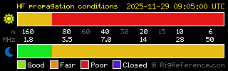
Radiometeorology
Current MF/AM conditions ©RigReference
Current atmospheric conditions and map of maximum
usable frequencies ©Paul Herrman
EXPLANATORY NOTE:
This section contains information and data pertaining to
atmospheric propagation (skywave) of radio and television
signals. It is probably of very little use to most
meteorologists or weather enthusiasts, though broadcast
engineers, DXers (people who have a hobby of receiving
long-distance TV and radio signals), and people with Asperger
syndrome who have this as a special interest might find it of
use.
-
Signal monitors
- Live AM/HAM
atmosphere conditions ©
Copyright Paul Herrman N0NBH, used under free license
- Live FM bandscans
- Live TV
bandscans
The FM and TV bandscans also include a breakdown for each receiving station. The particularly striking signals to watch for are long (900-1400 mile) receptions of low VHF (channels 2 to 6) TV channels. This is "sporadic E" (E-skip or Es) and if you can figure out the atmospheric conditions that correlate with E-skip and will allow it to potentially be modeled, you will have solved a major atmospheric mystery.
- Manual AM / shortwave monitoring (SDR)
-
Forecast models
- Hepburn tropospheric ducting index
General weather links
-
Government
- National Weather Service
- Environment Canada
-
Universities ©
- Plymouth State
- University of
Quebec at Montreal
- UCAR
-
Corporate ©
- The Weather Channel
- Weather Underground
- AccuWeather
- WeatherBug
About this page / legal disclaimers
This page contains a collection of images and links to assist meteorologists (such as myself) in producing forecasts. It includes links to radar, surface analyses, satellite images, model forecasts, upper-air soundings and maps, and the like. Some of the content on here is experimental. While most of the content on here is either public domain (U.S. government data) or freely licensed (Canadian and Japanese government data), there are some items that are copyrighted (television station RADARs, some forecast models, New York State government data, and the USPLN lightning detection maps) and may only be used and redistributed under the terms and conditions set by the copyright holder. Most of it is marked with the © symbol.
Note that some of the U.S. government-issued products linked
from here are to non-U.S. government sources. While they may try
to claim a copyright on their images, U.S. copyright law
requires a certain level of original creation to claim a valid
copyright, which in most such examples here is not the case.
No effort has been made to make this page comprehensive for the
entire United States or world. It is focused mainly on upstate
New York and the northeastern United States.
While this page has been made in good faith, neither
Fullervision.net nor its owner makes any warranty or statement
regarding the reliability of these products and will not be held
liable for anything stemming from its use. You alone are
responsible for what you do with this information.
Please note: Many of the tools on this page are meant to be
used by meteorologists trained in their usage. Amateurs are free
to peruse the materials, and if they can understand them, more
power to them. However, if you get in over your heads... don't
say I didn't warn you.
Fullervision Enterprises, Untld. 2002 / 2026